Wednesday, September 30, 2015

21 Gun Salute


MADAGASCAR WAS THE SITE OF A 6 MONTH BATTLE DURING WWII.


(Please excuse another WWII post. . . I find it rather fascinating)

The strategic location of Madagascar made it a key foothold in the Indian Ocean, and (as mentioned in a previous post), when France fell to Axis control, Madagascar went along with it.

In 1942, the British Navy had been backed into a corner in the Indian Ocean, and were headquartered in Kenya. The supply routes to ground forces in Africa and the fleet in the Pacific were threatened by the potential of Japanese naval forces in Madagascar. There was talk of Vichy France ceding Madagascar to Japan for that express purpose. Churchill saw this as too great a threat to ignore, and an amphibious assault plan was drawn out.

Map showing the landing site of the initial assault.


On May 5, 1942, Operation Ironclad took place. Assault forces landed in the northern tip of the island, facing about 8,000 Vichy troops, lead by Governor General Armand Leon Annet. Around 6,000 of those were local Malagasy infantry, or "tirailleurs," and the rest were mostly Senegalese.

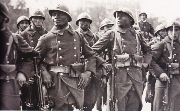
Senegalese Tirailleurs.
While the main attack pushed in from the north, a diversionary attack force landed in Tamatave (aka Toamasina, aka where the Africa Mercy is presently docked). 

Allied forces landing in Tamatave
The HMS Warspite accompanied by a Martlet patrol near Madagascar.
The following ground campaign progressed slowly for about 6 months, including another major ground assault named Operation Streamline Jane in September 1942. Eventually, the capitol of Antananarivo (then called "Tananarive"...who decided to add more syllables!?) fell, and and on the 6th of November, an armistice was signed.

British Battery position near Ambrositra, Madagascar.
RAF Lysanders on patrol over Madagascar after the Armistice.
After the war ended, as I mentioned, an uprising pushed the French to grant Madagascar its independence, and no more meddling European rule dragging them into wars. 

Alright. I promise not to make any more WWII posts. K?

À la prochaine!

Tuesday, September 29, 2015

22 - Two Little Ducks.


MADAGASCAR IS HOME TO A MASSIVE FOREST OF SPINY ROCK FORMATIONS CALLED "TSINGYS"


     The Tsingy de Bemaraha Strict Nature Reserve & National Park are home to a crazy and unique expanse of "karstic plateaus," known in Malagasy as Tsingys. Tsingy literally means, "where one cannot walk barefoot."

Yikes. And I yelled at people for running barefoot at CAMP!

     The formations were created by groundwater eroding away at the limestone landscape from below, while monsoon rain did the same to the surface. This resulted in the massive, bizarrely geometric trenches and crevasses between needle-like points. It's pretty much a bunch of clusters of giant knives sticking blade-up out of the ground. Sounds like a fantastic place to hang out.


     The completely unique geography of this area means it's home to many animals and plants that don't exist anywhere else in the world. The harsh environment creates a challenge to survive there, but it also helps ward off predators, and humans! The difficulty of exploring the region, and the many hidden nooks and crannies, means that new species are still frequently discovered there.

Does this not look like a suburban neighbourhood? SO WEIRD.

     Anyways, enough blabbing for this post. Enjoy some more mind-blowing pictures!

Crazy lemur is crazy.

'Till tomorrow!

Monday, September 28, 2015

23 is Number One!

MARCO. . .


                                                    . . .POLO! (named Madagascar)


Marco Polo in stunning 360m resolution (the "m" is for mosaic).

     Sometime in the 13th century, Marco Polo came upon the island of Madagascar. Apparently he miscalculated a tad, and thought he was in Somalia, in the port of Mogadishu. When I say "a tad," I mean he was actually around 2,000 kilometers off track. When recording his visit in his memoirs, as so often happens across language barriers, things got a bit jumbled. Polo ended up writing: "Madageiscar."

     Now, there are some discrepancies here, and it seems there's no definitive evidence he ever visited the island, and was perhaps *actually* in Somalia, but thought he was on some other, massive island. In any case, since the local inhabitants had no cohesive word for the island at that time, the name stuck.


     A Portuguese explorer, Diogo Dias, who definitely, actually arrived on the island in the 15th century gave it the name, "Sao Lourenco" (St. Lawrence). However, by that time, "Madagascar" had become popularized across maps. Sailors would apparently also refer to Madagascar as the "Island of the Moon."

And on that note, here's a picture from last night's lunar eclipse.


25 & 24: Pony up and stay out of Jack Bauer's way.


If I manage to get this post done in the next 10 minutes...I'll have 24 days to go.

LET'S DO THIS.

THE FLAG OF MADAGASCAR REPRESENTS THE FORMER RULING KINGDOM & NEW INDEPENDENCE FROM FRANCE.


     The red, green and white of the Malagasy flag is reminiscent of Christmas, but has absolutely nothing to do with it.


     I'm so great at segues.

    Anywhoo...I mentioned the Merina Kingdom in a previous post. They ruled over Madagascar for almost a century before France's invasion and colonization. One of the first kings is pictured below. As you can see, he's wearing a white and red tunic; these were the colours of the Merina Kingdom which are represented on the flag. Cool! The red and white are also the colours of the Indonesian flag, which is likely the region where many of the original settlers of Madagascar were from.

King Andrianampoinimerina

   
     The green on the flag represents the Hova caste from the pre-colonial Kingdom days. These were the middle-class, common folk, many of whom later led an uprising against the French to gain independence.


MADAGASCAR ALMOST BECAME A GIANT CONCENTRATION CAMP.


     I bet you think I'm exaggerating. I'm really not. Just before the Nazis conquered France in 1940, there was a plan to utilize the island of Madagascar, still a French colony at the time, as a site for the mass-deportation of Jews from Europe. Assuming they would sweep through England as easily as they did France, the plan involved use of the commandeered British merchant fleet to transport Jews en-mass to Madagascar, where they'd be governed by the SS.

A propaganda poster outlines the plan...

     Of course, the Brits were not so feeble as expected, and this plan never came to fruition. The Nazi's alternative solution, as it turned out, was all too terrible.

Friday, September 25, 2015

26 Bones in the Foot.

26 days to go, and time for another fact:


OVER 11 MILLION PEOPLE IN MADAGASCAR HAVE NO ACCESS TO SAFE DRINKING WATER.


     Wow. That's almost half the population of the country. As of 2012, Madagascar had the FOURTH WORST water access in all of Africa. Water, Sanitation, and Hygiene (AKA "WASH") remain some of the biggest challenges related to poverty and lack of infrastructure in developing nations worldwide, and Madagascar is no exception. When it's hard to even get enough water to drink, it means no extra water for anything else. No water means no washing hands after you do your business. No washing hands means transmission of disease through food, or direct contact with the mouth & nose. Transmission of disease + limited access to healthcare = severe illness and sometimes death. Can you say domino effect? 

     But when you have to walk up to 6 hours to get water, washing your hands with it doesn't exactly seem like a priority. 

     Oh. And speaking of domino effects...imagine making any time to walk to, attend, then walk home from school when you've also got to walk for hours to get your water. 


     WASH is a major priority for the UN, and was, of course, part of the Millennium Development Goals (and now the new Sustainable Development Goals). This means that every nation in the UN has signed an agreement to strive to improve water access, sanitation, and hygiene for each of their citizens. 

     If you've never heard of the Millennium or Sustainable Development Goals, check out this video:

     Onions. Just blame it on the onions. 

     So, here's the good news and the bad news. 

     The good news is, the UN's target goal for drinking water access was met in 2015. Over the last 25 years, the number of people in the world without access to safe drinking water and basic sanitation has been cut in HALF! African nations still lag behind the rest of the world, but things are getting WAAY better.

     And now the bad news. While safe water is getting easier to access, the world's water supply continues to dwindle, and this is, of course, most notable in northern Africa. The UN reports that water scarcity affects over 40% of the world's population, and that number is going to keep going up.

     So, what does this mean for those people in Madagascar, who rely on their feet to get their water every day? Well, although only half the population currently has easy water access, that is still a MASSIVE IMPROVEMENT from 1990, when only 29.5% had access. Things are improving, and organizations such as UNWater, water.org, and WaterAid are making tremendous progress. Consider supporting these organizations if you have a couple bucks to spare. Got a birthday coming up? Many of these organizations have cards and gifts you can purchase as a gift in a friend's name. Or, instead of taking someone out for dinner for their birthday, make a donation in their honor. I'd be thrilled to receive such a gift (*wink wink nudge nudge*)! 

Thursday, September 24, 2015

28-27 Double Down

Oh dear. I'm already getting behind on this.

Well, time to double up!


MADAGASCAR WAS COLONIZED BY THE FRENCH IN 1896. 


    The Kingdom of Madagascar, also known as the Merina Kingdom, lasted from the early 17th century until Madagascar was invaded and colonized by the French in the 1890's. Prior to colonization, the country was shifting to western ideals; improving access to education, modernizing the army, and adopting a British-style legal system. Then the French were like, "hey! We used to have a trade agreement with you guys, and now you're ignoring it and  getting all buddy-buddy with the British! Better invade." This sent the royal family into exile, and led to fact #27. In 1960, after only 64 years of French rule, Madagascar gained their independence as an autonomous, and eventually democratic republic. Perhaps this was to avoid the inevitable complications of counting above 60 in French.


THE OFFICIAL LANGUAGES OF MADAGASCAR ARE MALAGASY AND FRENCH.


     The Malagasy language traces back to the early settlers of the island, who sailed west from the Polynesian islands. It is, thus, quite distinctive from the languages of its closer African neighbours, but similar to the languages of Indonesia, Malaysia, and the Philippines. The written Malagasy language utilizes the Latin Alphabet, with the exception of the letters Q, U, W, and X. They're silly letters anyway. Who needs 'em. Um. Oh. I guess I do, since I just used U and W quite a bit. Shoot. I just used Q, too. X. X is a silly letter. Why does it exist anyw-...um...nevermind. Miala tsiny (sorry).

     The language also borrows some elements from Arabic, and another form of written Malagasy uses Sorabe script, which looks like this:


     Of course, the French language was introduced during the French colonization. Being such a widely-spoken language internationally, and especially among other African nations, it has remained a major second language. It is, however, more prevalent among the educated and well-off. 

     Well, that's it for me today. Time to brush up mon Franglais et puis get some dormir.

Tuesday, September 22, 2015

29 Knuts in a Sickle

     With 29 days to go, here's fact number 29 of Some Things You Probably Didn't Know About...Madagascar!


THE CURRENCY OF MADAGASCAR IS THE ARIARY REALLY HARD TO PRONOUNCE.


        The Ariary is the currency of Madagascar, having replaced the Malagasy Franc in 2005. Every time I try to say it, I feel like I'm saying, "'airy 'arry" (Hairy Harry). It seems there's a lot of repeated syllables in Malagasy words. So since the difficult pronunciation is going to be a recurring theme, let's focus on some somewhat more interesting facts about the money!


     1 Ariary is equal to...not very much. let's rephrase this. 100 Ariary is equal to about 4 Canadian cents. The notes range from 100 Ariary to 50,000 Ariary, and feature famous landmarks and wildlife of the country, including lemurs, zebus, and tsingys. If you're wondering what a tsingy is, that's another fact for another day! Isn't this exciting? The suspense must be killing you. Let's carry on for now, shall we?

     The Ariary is further divided (yes, unlike our penniless nation they have currency smaller than 4 cents), into (and here it gets REEEEALLY hard to pronounce) Iraimbilanja. Iraimbilanja are 1/5 of an Ariary. An Iraimbilanja equals 1 Malagasy Franc. It seems they are phasing out the Franc, with more recent denominations having both Ariary and Franc notation, but the Franc becoming less and less prominent. 

     Bonus fun fact of the day! The Ariary is one of only two non-decimal currencies in the WORLD. Why not decimals you ask? Because fractions are clearly way more interesting. Always halving controversial opinions, and causing division among friends. 

     See what I did there? Ok. You're right. I'm trying to make money way more interesting than it is. Fine. Just enjoy these pictures until tomorrows post. 

WAAAT Do you see that heptagonal coin!? Seven sides!! That's crazy! 


Monday, September 21, 2015

30 Days Has September...


30.

The countdown begins.

That's how many days before I leave.

I feel like there's 300 things left to do, but the end is in sight.

Actually, there's only 13 things on my to-do list, so I guess that just leaves the other 287 as things I need to pack.

I'm gonna need a bigger bag.


     But in the meantime...I'm going to attempt to do one blog post a day. I'm hoping this will help keep me motivated and accountable for all the other stuff I need to do, and not, in fact, be another way of procrastinating. :/

So, here's post number ONE, of "30 Things You Probably Didn't Know About Madagascar (and possibly more things once I actually arrive and discover them)!"


MADAGASCAR IS THE FOURTH LARGEST ISLAND IN THE WORLD!


     At 587,040 square kilometers, it's almost the size of Saskatchewan. Only the islands of Greenland, New Guinea, and Borneo are larger. I believe the biggest island I've ever been on is Vancouver Island, which is, like, pretty big. Madagascar is 18 times bigger. The coastline is almost 5,000 km long. That would take about 6 months to walk around.


     During my stay, I won't be doing much walking around on the island itself, but I will be walking about 5 km a day per shift. Who needs exercise when you're a nurse!

     If you're saying to yourself right now, "Wait, self, isn't Australia gigantic and almost-definitely bigger than all of those islands?" Well, you're right. Apparently, though, Australia doesn't actually count as an island, it's a "Continental Landmass." So it's SO BIG it gets bumped up to the heavyweight category and doesn't get to be biggest. TIL.

Stay tuned tomorrow for fact #29!